|
|
|
|


|
 November 2012Israel's boundaries.
|
||||||||||||||||||||||||||||||||||||||||||||||||||||||||||||||||||||


|

|

|
Interview with Daniela Santus
Prof. of Cultural Geography, University of Torino (Faculty of Languages)
Interview with Ofir Haivry
Senior Fellow, Shalem Center, Jerusalem
| Israel's boundaries |
|
|
History
.jpg) The "Land of Israel" is the territory that, according to the Bible (Genesis 15:18-21; Exodus 23:31; Numbers 34:1-15), was inhabited by the 12 tribes of Israel, which were assigned the "Promised Land," corresponding to the lands west of the Jordan river (the land of Canaan), those east of the Jordan River (currently Jordan), and those north of Tiberias (currently southern Lebanon and south-east Syria).
The "Land of Israel" is the territory that, according to the Bible (Genesis 15:18-21; Exodus 23:31; Numbers 34:1-15), was inhabited by the 12 tribes of Israel, which were assigned the "Promised Land," corresponding to the lands west of the Jordan river (the land of Canaan), those east of the Jordan River (currently Jordan), and those north of Tiberias (currently southern Lebanon and south-east Syria).
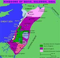 The "Kingdoms of Israel" (Saul, David, Solomon, the kingdom of the Hasmoneans, and Herod's Dyansty) had, according to historical records, variable boundaries, with less sovereign territory than the Tribes, but more economical and political influence on surrounding lands.
 "Judaea" was the Roman province from the Dead Sea to Caesarea, including current Judea and Samaria. Only in the 2nd century AD the Roman Emperor Adrian changed its name to "Palestine," in order to humiliate the Jews and eradicate their ties with Jerusalem, then renamed "Aelia Capitolina". The territories north of Caesarea to Damascus were known as the "Province of Syria."
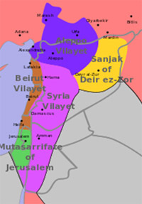
Subsequent foreign rulers (Byzantines, Arabs, Crusaders and Mamluks) have administrated the territories corresponding to current Israel, the Palestinian territories, Lebanon, and Syria, and modified their boundaries. The Ottomans divided the territory into vilayet (regions) and sanjak (provinces). What is referred to as "Near East," then comprised the vilayet of Beirut, from Beirut south to current Galilee, the vilayet Syria, from Damascus south to current Samaria and Jordan, as well as the sanjak of Jerusalem, also known as "South Syria," from Jerusalem south to Gaza and Beer Sheva.
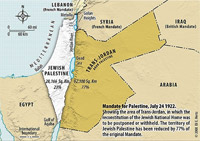 In 1916, France and Great Britain defined their areas of influence over the territories of the Ottoman Empire. Great Britain retained the territories crossing Baghdad and Amman down to the Mediterranean coast of current Israel. Taking the Jordan river as a dividing line, the British called the territory "Palestine." East of the Jordan was named "Transjordan," or "Arab Palestine," to distinguish it from "Jewish Palestine," the one west of the Jordan, where Jewish communities settled and were to be the future "Jewish national home."
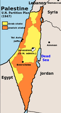 The first attempt to reach a compromise on the partition of Palestine was the recommendation of the British Peel Commission (1936-1937), which assigned to the Jews territories in current Galilee and a small part of the coast, while Samaria, Judea and the Negev would remain in Arab hands. Following the Arab refusal and the Arab uprising, negotiations stopped until 1947, when the United Nations proposed the Partitioning Plan, based on the ethnic distribution of the territory. Jews were assigned a small part of fertile lands and the Negev, with a population 56% Jewish and 44% Arab residents. Arabs were assigned part of Galilee, Samaria, Judea, Gaza and part of the eastern Negev with a 99% Arab population.
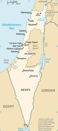 Arabs refused the partition and caused the Independence War (or War of Liberation) of 1948-1949, which Israel had to fight against a coalition of Arab States. During the war, Israel captured territories in the North, annexing the entire Galilee, and in the South, annexing the western Negev.
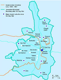 Between 1949 and 1967, the armistice lines were left untouched: the northern border with Lebanon corresponds to the actual one; the Golan was still under Syria's control. Jordan captured and annexed the West Bank and part of Jerusalem including the Old City, forbidding Jews access to the Western Wall and Israeli Arabs access to the mosques. Moreover, the access to Mount Scopus, where the Hebrew University of Jerusalem sits, had to be guaranteed through the Mandelbaum Gate, but only foreigners and religious dignitaries could cross the border.
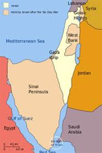 Israel's boundaries dramatically changed after the Six Day War in 1967, when Israel captured and annexed East Jerusalem from Jordan, the Golan Heights from Syria, from where Syrian soldiers used to snipe at Israel's communities. Israel also captures the West Bank from the Jordanians as well as Gaza and the Sinai from the Egyptians, who would never claim sovereignty over Gaza. Jurisdiction on part of the West Bank is still disputed between Israel and the Palestinian National Authority.
Israeli concessions
- Territories captured during the Six Day War were held to negotiate peace (restitution in exchange of recognition), concluded with Egypt in 1979 and with Jordan in 1994.
- Israeli governments, although not annexing all captured territories, favored Jewish settlements on the new lands. Therefore, in order to sign peace with Egypt, Israel had to withdraw from Sinai in 1982, disengaging 18 settlements.
- With the Oslo Agreements in 1993, Israel withdrew from Gaza and Jericho, maintaining military presence for the only defense of Israeli settlements.
- In summer 2005, Israel disengaged from Gaza, evacuating 21 communities, by implementing the Sharon disengagement plan in order to advance peace talks.
Current Borders and Boundaries
Egypt: the Peace Treaty signed in 1979 defined borders.
- Over the last 10 years, through the border with Egypt, Sudanese, Eritrean and Congolese asylum-seekers smuggled into Israel, after surviving torture camps in Sinai, where Bedouin smugglers held them.
- After the recent Arab revolutions, the border between Egypt and Israel has become increasingly insecure from the presence of Islamist terrorists in Sinai, also coming from Gaza, posing a threat to Israel's security and Egypt's stability.
- Since the first terrorist attack from Sinai against Israeli civilians and soldiers on 18 August 2011, another 23 attacks have followed, targeting mainly Israeli border troops.
Jordan: the Peace Treaty signed in 1994 defines borders.
- The peace treaty notwithstanding, conflict at the border remains dormant. In 1997, a Jordan soldier shot a group of girls visiting "the Island of Peace," a nature site on the border between the two states.
Lebanon: borders run through the "Blue Line"
- The UN Resolution 425 of 1978, which constituted UNIFIL (United Nations Interim Force in Lebanon), defined the "Blue Line" as border, ordering Israel to withdraw from Lebanese territory – which indeed happened in 2000. Israel had invaded South Lebanon in response to Palestinian terrorist activities responsible for continuous attacks and infiltrations into Israeli territory.
- The "Blue Line" does not entirely correspond to the "Green Line," defined by the 1949 armistice on the ancient borders between Lebanon and Mandate Palestine.
- After the "Six Day War," Israel captured the Golan Heights, including the Sheba'a farms and the village of Ghajar, over which Lebanon claims jurisdiction. However, during the French Mandate, these territories were part of Syria. The Sheba'a Farms have a strategic interest for their location allowing observation over Lebanon and Syria. Ghajar is on Israeli-controlled territory, but the population is half Lebanese, with consequent restrictions of access.
- Infiltrations by Hezbollah, the extremist Shiite movement that controls South Lebanon and part of the central government, in 2006 caused the Second War of Lebanon, remembered for the abduction of two Israeli soldiers assassinated by Hezbollah terrorists, for the constant rocket firing, as well as for the falsification of journalistic reports on Israel's raids.
Syria: the 1949 armistice defined borders, changed in 1967 after the Six Day War.
- The "Green Line," which is the armistice line of 1949, included the Israeli territory of Galilee and the Lake of Tiberias (in Hebrew, Kinnereth).
- After the Six Day War, Israel captured the Golan Heights, where Syrians used to snipe at Israeli communities (kibbutzim and towns). In 1981, Israel annexed the Golan, extending its jurisdiction over it.
- Because of the current Syrian civil war, this border has become increasingly dangerous. In July and September 2012, Syrian forces shelled rebel villages on the Israeli border.
- Humanitarian aid offered by Israel to Syrian population was refused notwithstanding International Red Cross mediation. Ayoub Kara, Likud Member of Knesset, deals with "indirect" humanitarian aid to refugees. Israel commits to accept refugees who manage to cross the border, but fears that Assad's collapse may turn the region into an anarchy terror zone, with consequent terrorist infiltrations among refugees.
Palestine: boundaries are defined by the 1995 Agreement consequent to Oslo.
- The Green Line defines the armistice boundaries between Israel and Jordan, which in 1949 annexed the West Bank. Improperly, the "Green Line" is used to define the legitimate borders of the potential Palestinian State.
- 1993 Oslo Agreements and 1995 Interim Agreement divided the West Bank and Gaza in administrative areas under complete Palestinian Control (areas A), under Palestinian civil control and Israeli military control (areas B), and under complete Israeli control (areas C).
- After the 2005 disengagement from Gaza, this administrative division remains valid only in the West Bank, while borders with Gaza are under Israeli blockade aiming to weaken Hamas, which secured power in 2006 after free elections followed by a civil war.
- Areas A and B, controlled by the Palestinian National Authority, constitute the 39% of the West Bank, where the 96% of Palestinians live, and are divided by areas C, controlled by Israel for the presence of Israeli settlements.
- Because of terrorist activities of the Second Intifada, Israel intensified the control over the Palestinian population, limiting freedom of movement, in the attempt to hinder the barbarous suicidal attacks. Thanks to the separation fence, 700 km-long with 10% of wall, between Israel and the West Bank, great part of road blocks have been removed, as well as temporary check-points, while areas B have been progressively handed over to the control of Palestinian police. Fifteen checkpoints guarantee the movement between Israel and the West Bank.
- Gaza remains a dangerous border for the activities of Hamas, including rocket firing and kidnapping attempts of Israeli soldiers (as in the case of Gilad Shalit).
- Borders with the West Bank are still disputed, in the context of a possible agreement with Palestinians on the future of Israeli settlements and on the question of border security.

|
Interview with Daniela Santus Prof. of Cultural Geography, University of Torino (Faculty of Languages) |
|
|
 Central to the debates on the Arab-Israeli conflict, there is the question of Israel’s borders, which, over the years, have significantly changed because of the wars: from the Green Line, to the Blue Line, to the “red line bordering the territories administered by PNA (Palestinian National Authority) and closed to Israelis. Often, the failure in defining borders is considered a deliberate Israeli policy, aiming to expand its territorial control and to suffocate Palestinians in between legitimate and real borders. Are Israel’s borders really the central focus of the conflict, or are they used for the anti-Israeli discourse? What meaning does the expression “Israel’s borders have, beyond its geographical content?
Borders, as should be known, are by their nature extremely transient. Would someone nowadays talk about Jugoslav or Soviet borders? And would someone dare to claim sovereignty over Istria or Dalmatia within Italy’s borders? If we talk about Israel, however, “borders or armistice lines become inviolable, or, better, violable insofar the ultimate goal is to wipe the Jewish State off the maps. Actually, the land of Israel, renamed Palestine by Roman Emperor Adrian in 135 AC (originating from the name of Greek Philistines, transferred from that area by Nebuchadnezzar), has always been wider than the narrow strip that is now Israel. Current Israel, geographically smaller than the Italian region Piedmont, does not represent the territorial extension of the historical Israel. Indeed, even the Romans had to divide that territory in three provinces for governing purposes: Palestina Prima (the central part of the country), Palestina secunda (including Galilee, the Golan and the northern part of present Jordan), and Palestina tertia (the Negev, part of Sinai and the southern parts of Jordan). Taking a look at this region in more recent times, it is worth noting that right after the First World War and the beginning of the British Mandate on Palestine, borders were changed without making a big deal out of it: the British cut the territory into two parts, creating Transjordan and occupying the territories on the other side of the Jordan, where a Jewish national home would be founded but favoring Arab interests. Lastly, the borders defined by UN Resolution 181 were violated by Arab armies, which attacked the Jewish State just 8 hours after its birth. I am convinced that people who measure borders in centimeters act in bad faith: they are the same people who still speak of Gaza as an “occupied territory, although Israel has disengaged in August 2005, since which there is no Jew in Gaza (while there are 2.5 million Muslim Arabs within Israel’s borders who enjoy the same rights of their Jewish fellow citizens).
Borders also distinguish cultural communities. In light of recent developments in the Middle East, what has changed in terms of cultural borders between Israel and the rest of the Arab-Islamic world (also with reference to Salafists in Lebanon, a hostile border, and to Islamists in Sinai, a “peaceful border)? Thinking of the Arab Spring in the whole Arab-Islamic world, what do Israel’s physical and cultural borders represent, with reference to the Arab minority within Israel and to the Palestinians, who contend the frontiers in the West Bank?
The Arab Spring is such only to the eyes of Western media, which love believing in tales. Just as when Arafat, signing the Agreement with Rabin in 1993, declared he signed that treaty with the same attitude as Mahomet’s when he signed the al-Hudaibyah Treaty with the inhabitants of Mecca, committing to keep his forces out of that city for ten years. The Western medias were inebriated listening to Arafat’s words... "Arafat quotes the Prophet Muhammad to reinforce peace! " ... without knowing that the episode in the Quran is an undertaking that was not honored: Muhammad invaded the city Mecca two years later, imposing conversion to Islam and killing the others. The same can be said for the Arab Spring of the Muslim Brotherhood, which erased that little secularity left in their countries (think of Tunisia and the adoption of laws against women in the aftermath of the revolution). What they have in common is certainly not culture, but hate for Israel. And today Israel knows it cannot count on anybody but on itself. However, Israel’s strength, a small country and 60% desert, does not lie in its army or in its weapons, but in its identity. Israel is a nation-state whose majority population is Jewish, born to protect them from persecution and for national, spiritual, and cultural rebirth.
“I will be what I will be, answered God to Moses asking what he should tell Israelite slaves in Egypt when they would inquire him about who sent him to free them. And maybe that’s the reason why the Jewish people have always been so attentive to identity. Actually, every society organizes its spaces, produces its territory, shapes its landscapes in terms of signs and symbols of its material culture (fields, houses, streets, cities…) and of its immaterial culture (toponyms, sacred places, borders…). This leads to the identification of the individual with a certain place, of a group with a certain territory, of a society with a certain landscape, which defines a precise belonging, a certain mutual link, which is not a cause and effect link, but derived exclusively from a process of cultural objectification in constant development. Speaking about Israel, we cannot forget that according to the Jewish tradition not only had God created the man “in His own image, but also emphasized the concept of nation, promising Abraham his descendants would be “a great nation. And this does not mean supremacy. The Jewish tradition does not divide human beings into categories, as instead the Islamic tradition does dividing people into dar al-islam (the abode of Islam, the believers), and dar al-harb (the abode of war, the infidels to be subjugated). According to the Jewish tradition, all nations are blessed because, through Abraham, God will bless “all peoples of the earth. But in the Mishnah it is written that “If I am not for myself, who will be for me? And when I am for myself, what am 'I'? And if not now, when’ Therefore, if Israel did not lose its specificity in 1967, surrounded by Arab enemies who wanted to throw the Jews into the sea, it won’t lose its specificity now, although freezing Arab springs bear down on its borders.
The Arab minority in Israel enjoys all rights and is well integrated, apart from some major difficulties, which affect Jews as well, like housing crisis, increasing unemployment, and lack of workers’ protection. Israel’s Arab citizens can vote and be elected in the Parliament: there are Arab parliamentarians, Arab mayors, Arab physicians, Arab lawyers, Islamic schools, and Christian schools. Freedom of belief is guaranteed and respected. From a recent survey, it comes out that Israel’s Arab, Muslims and Christians alike, wouldn’t apply for Palestinian citizenship should a Palestinian State be born. Young Christians Muslims, and Jews grow up together, even go to the same schools, and play football together. In Metulla, on the border with Lebanon, there is the Canada Sport Center, with ice skating facilities for the Israeli hockey team. Well, sport teams are composed of young people of different ethnicities; no matter if they are Arab or Jewish.
I feel sorry for Palestinians in the West Bank and in Gaza, because they are victims of their own leaders: indoctrinated with lies since childhood, convinced that dying as martyrs is their biggest aspiration. Children in schools and people in mosques are taught to imitate assassins and mass murderers, considered as heroes: when you raise children in schools teaching them to become martyrs for the cause of annihilating the Jewish State, it is highly improbable that they will be peaceful neighbors, supporting peaceful coexistence.
Then there are women in Gaza who choose Israeli hospitals for giving birth to their kids, such as Iman Shefi, who gave birth to two twins in Ashqelon, while her fellow citizens fired rockets on Israel. Or like the parents of more than 1500 children who chose Israeli hospitals for their children’s cardiac and neurosurgeries. But there are also Palestinian homosexuals, who risk death by hanging in Gaza or in the West Bank, besides torture and humiliation in Palestinian jails, and who ask for and obtain political asylum in Israel. There are also Palestinian physicians who choose to intern in Israeli hospitals and then go back to West bank or Gaza for work.
How to forget, then, the projects of the “Peres Center for Peace, which promote activities that include sport, agriculture, education, technology, and art. Two million and a half strawberry plants have just been planted in Palestinian territories for the project “Strawberries for Peace, twelve IT centers have opened in West Bank, projects on water desalinization and water cleaning are implemented; just to give a few examples of cooperation from which one may understand how Israel’s borders, both cultural and geographic, are so permeable and have different gates beyond which there’s always a stretched hand, unless you try to cross the gate with an explosive belt fastened on your sides.
How does the use of expressions referring to geographical realities that do not exist any more influence the perception of the conflict and of Israel? For instance, the use of “East Jerusalem to describe the Arab part of the city implies that there is a Western Jerusalem geographically divisible as in 1967. Again, the expression “Respect the Green Line suggests it may be possible to go back to the 1949 borders.
I have to state beforehand that Jerusalem is the capital of Israel and so it has been since the times of King David. That’s it. It is not mentioned a single time in the Quran. On the contrary, it seems that ‘Abdallah b. Mas’ud, a follower of the Prophet, once declared, “Even if the distance between me and Jerusalem was only two parasangs, I would not go there. Moreover, Jerusalem has never been a capital of the Caliphate (besides Mecca, Baghdad, Damascus, and Samarra have been chosen as capitals). Similarly, Jerusalem has not been chosen as capital of Jordan when, between 1948 and 1967, it occupied the eastern part of the city. Furthermore, Arabs have constantly refused the “two peoples-two states solution. Even when Barak, in 2000, offered the Arab neighborhoods of East Jerusalem as capital of the Palestinian state, Arafat refused the proposal. In front of such an incredibly paradoxical situation, the world should have opened its eyes, but kept them firmly closed.
But if you ask me what damages improper geographical expressions cause, I can assure you that they cause enormous damages. I have just completed a survey among 250 undergraduate students, which I use to evaluate their knowledge at the beginning of the course. Well, 25% of the students told me that Mecca is in Palestine, 20% that it is in Israel; 15% believe that Islam is the first monotheistic religion of the world; 30% believe that Gaza is a territory occupied by Israelis and 30% that Jews can be elected in the Parliament of Hamas; 90% believe Arab Israelis do not have civil rights; 20% think PLO was an organization fighting to give lands to Jews, while 25% believe it was an organization fighting to guarantee freedom of religion in Palestine; 40% of the students believe Israel is as big as Italy, while 20% believe it is double Italy’s territory. Last but not the least, 10% of my students believe that there are 5 countries in the world whose majority population is Jewish, while 5% believe that there are 10 countries in the world whose majority population is Jewish. I cannot but think that there is a plan under this confusion: someone created it and nourishes it.
Speaking instead of a future Palestinian State, usually one thinks of Palestine as a negative identity to Israel. The existence of Palestine is linked to occupation, indeed the usual expression is “occupied Palestinian territories, while Palestinian culture is linked, negatively, to the existence of Israel, celebrated by the nakba (catastrophe). Can we talk about “Palestinian geography today, as a territorial and cultural community?
Somehow, yes. Although Palestinians are not a well defined people: they live in Gaza, in Judea and Samaria (the historical regions of today’s West Bank), but they are the two thirds of the Jordanian population and have a diaspora that goes from Kuwait to the United States. Not to talk about stateless Palestinians in Lebanon and Syria. And supposing it is true that just two centuries ago, the Jews “decided that their land was the historical Land of Israel, defined by the Bible; it is equally true that the Palestinians have localized their homeland in Israel just after 1967, which means after the consolidation of the Jewish State (not even when it was founded!). However, in these days the Arabic daily newspaper distributed in the West al-Hayat announced that Hamas may declare the independence of Gaza. We could in short find ourselves with three Palestinian entities (let’s not forget that Jordan is the first Palestinian State created by the British thanks to the subdivision of the Mandate) and a Jewish State that lie all on the same area in which the Jewish people was born, where its culture has developed as well as its political organization; this equates to saying four states for two peoples: three Palestinians and one Jewish.
Abu Medin, former Palestinian Ministry of Justice, has over the years repeatedly accused Palestinian Security Forces of not having protected the infrastructures of former Israeli settlements, including water supply and electricity, which were instead demolished by ten of thousand Palestinians that assaulted the areas just evacuated by the Israelis in 2005. This in addition to the numerous charges of Palestinians accusing armed groups and clans of Gaza of occupying the lands of former settlements. Moreover, Abu Medin revealed that the PNA Center for Agricultural Development failed to manage the green houses left by the Israelis. Now with Hamas in power, all those lands, which could have contributed to economic welfare of Palestinian families, have been transformed into launch pads for daily firing of rockets on Israel.
All this serves the Western rhetoric, which has not even realized that Gaza Strip is no more definable as “occupied territory, which by the way is a wrong expression even with reference to the West Bank. Indeed, the line separating West Bank and Israel, the so-called Green Line, is the line that between 1948 and 1967 signified the “cease fire, defined by the 1948 Armistice of Rhodes signed by Israel with Jordan and Egypt (for the control of Gaza). This armistice line cannot be considered a border, because it represents the position of enemy troops at the moment of the cease-fire. According to the IV Geneva Convention of 1949, “occupied is a territory belonging or claimed by another sovereign state and occupied by a military action: since the West Bank does not belong and is not claimed by any sovereign State, a proper definition should be “contended territories, since the parties contend their sovereignty. The Palestinian administration has different zones of autonomy, internationally recognized by treaties signed by Israel and the Palestinian Authority. The same transfer of power to the Palestinian Authority makes it difficult to talk about “occupied territories, in terms of art. 6 of the IV Geneva Convention and previous 1907 Hague Convention, which establish that a territory is to be considered occupied when it remains under the effective control of the occupying power. It is not the case of the West Bank, where 98% of the Palestinians live under the PNA controlled areas.
The birth of the Palestinian Authority in 1994 has not contributed to the independence of Palestinians. No strategy for boosting economy and employment has been implemented. The projects of industrial parks, even if they exist, have never been implemented, and no measure to attract investments has been adopted. The Palestinian leadership has only created big economic monopolies that now control petrol, flour, sugar, cigarettes, cement, and steel. These monopolies have only enriched the leaders of the Palestinian Authority. The result of all this is the real nakba (catastrophe) of the Palestinian people, since the labor market is dependent of the Israeli economy. This is disconcerting, above all as that Palestinian economy is constantly supported by annual donations of the European Union, the Arab League, the World Bank, the UNRWA, besides funds given by national governments, including Italy, which allocates budgetary funds for assisting the Palestinian Authority.
What is common to the Palestinians, which makes of them a “cultural community is, probably, not the desire for territorial self-determination (which they have repeatedly refused to do, in 1948, in1967, in 1979 and finally in 2000, preferring each time violence to peace), but the hatred toward Israel. With the return of the unattainable dream of a Greater Palestine in the collective discourse of the Palestinians, (a dream induced by the leaders, in order to whitewash their corruption and illegality), even the last hope for compromise vanished: we will see if Hamas will have the courage for self-determination, or if the “armed struggle for liberating the oppressed will represent the usual rhetoric of survival, at the expense of peace and the necessity of rolling up one’s sleeves.
|
Interview with Ofir Haivry Senior Fellow, Shalem Center, Jerusalem |
|
|
 Central to the debates on the Arab-Israeli conflict, there is the question of Israel’s borders, which over the years have significantly changed because the wars: from the Green Line, to the Blue Line, to the red line bordering the territories administered by the PNA (Palestinian National Authority), precluded to Israelis. Often, the failure in defining borders is considered a deliberate Israeli policy for expanding its territorial control and suffocating Palestinians in between legitimate and real borders. Are Israel’s borders really the central focus of the conflict or are they used for the anti-Israeli discourse? What meaning does the expression “Israel’s borders have, beyond its geographical content?
Many countries have areas or borders the sovereignty over which is disputed. Morocco's annexation of Western Sahara is one example, the India-Pakistan border in Kashmir is another. In Europe, the status and borders of Kosovo are disputed, and the same is true for the borders of Armenia and Azerbaijan or Bosnia-Herzegovina. Even within the European Union, the border between the two parts of Germany was annulled only 22 years ago, and British rule over Gibraltar is still not recognized by Spain, after hundred of years. There are many more such cases all over the world, so Israel's problem with borders is by no means unique.
Moreover, the true source of the Arab-Israel conflict is not territorial dispute. There had been anti-Israeli wars waged by the Arabs long before Israel started ruling the territories. But every time an Israeli government has offered to give up virtually all of the disputed territories (such as in 2001), the Arab answer has been, and still is, to deny the legitimacy of Israel as a Jewish state. The Arabs claim the "right of return," whereby millions of Arabs would be allowed into Israel and consequenlty destroy it as a Jewish state. Is that not the real "territorial expansion" and "suffocating" of Israel?
Borders also distinguish cultural communities. In light of recendevelopments in the Middle East, what has changed in cultural borders between Israel and teh rest of the Arab-Islamic world? Also with reference to Salafits in Lebanon, a hostile border, and to Islamists in Sinai, a “peaceful border. Thinking of the Arab Spring in the whole Arab-Islamic world, what do Israel’s physical and cultural borders represent, with reference to the Arab minority within Israel and to the Palestinians, who contend frontiers in the West Bank?
The expression "Arab Spring" does not truely describe what is happening in the Middle East. A better name would be the "Arab Autumn," of unstable, unforseen changes. This change comes after two generations of immobility under dictators who stabilized their rule and the borders, but destroyed their peoples.
Now, these forces, unleashed by the changes, are changing the face of the Middle East, what ever the outcome. Much is made of Islamist and Salafist challenges, but I believe there are many others, and the most important one will be the probable sectarial and tribal disintegration of the current state. Sudan has already been formally divided between the Muslim North and a Christian South. Iraq is de-facto divided between three quasi-states, Arab-Sunni, Arab Shia and Kurdish states. Syria is on the same path with Alawites, Shias and Druze forming enclaves; Lebanon is already sectarianly divided. Lybia is also gradually fracturing among tribes, and similar trends are observable in other Arab states, from Saudi Arabia to Morocco. Indeed, even among Palestinians, it seems that Gaza and the West Bank are going their own separate ways.
There will naturally be a resurgence of terriorism, but I suspect it will be far more fractured and intercine, and will be directed against the Arab thmselves, more than against Israel or the West. Within this scenario, it appears that Israel remains an island of stability, prosperity, and freedom. It is no chance that so many African migrants and Palestinians approach Israel's boders each day, attempting to enter. It seems that despite all the rhetoric against it, Israel is the place everyone in the Middle East secretly wants to be in.
How does the use of expressions referring to geographical realities that do not exist any more influence the perception of the conflict and of Israel? For instance, the use of “East Jerusalem to describe the Arab part of the city implies that there is a Western Jerusalem geographically divisible as in 1967. Again, the expression “respect the Green Line suggests it may be possible to go back to the 1949 borders.
The Green Line has never been anything other than a cease-fire line and has repeatedly been changed. The use of anachronistic terminology is certainly suspect in this context. After all, is it plausible for an Italian, today, to talk of “respecting the pre-1945 borders of Dalmatia? Or of restoring "East Berlin"?
|
|
|||||